Note
Go to the end to download the full example code.
Thredds resources for GUI
from datetime import datetime
from opendrift import test_data_folder as tdf
from opendrift.models.oceandrift import OceanDrift
from opendrift.readers.reader_netCDF_CF_generic import Reader

o = OceanDrift(loglevel=0)

thredds_resources = open(tdf + '../../opendrift/scripts/data_sources.txt').readlines()
thredds_resources = [t.strip() for t in thredds_resources]
times = {}
WARNING: from next version (1.14.10), loglevel of 0 will give no logging, please change to 10 for DEBUG
13:24:52 DEBUG   opendrift.config:168: Adding 17 config items from __init__
13:24:52 DEBUG   opendrift.config:178:   Overwriting config item readers:max_number_of_fails
13:24:52 DEBUG   opendrift.config:168: Adding 5 config items from __init__
13:24:52 INFO    opendrift:569: OpenDriftSimulation initialised (version 1.14.10 / v1.14.10-27-gff3ada1)
13:24:52 DEBUG   opendrift.config:168: Adding 19 config items from oceandrift
13:24:52 DEBUG   opendrift.config:178:   Overwriting config item seed:z
Open each thredds dataset to check contents and spatial coverage
for t in thredds_resources:
    if t.startswith('http'):
        start = datetime.now()
        print('\n#%%\n%s\n' % t)
        r = Reader(t)
        print(r)
        ts = str(datetime.now() - start)
        times[t] = ts
        print('Time to open reader: ', ts)
        if r.global_coverage():
            lscale = 'coarse'
        else:
            lscale = 'intermediate'
        r.plot(lscale=lscale)


#%
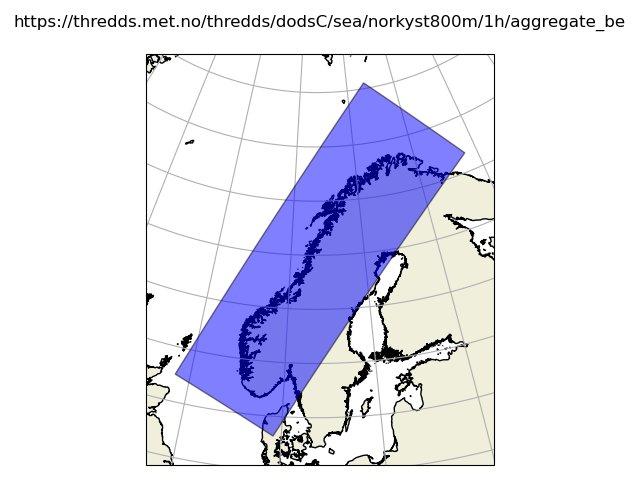
https://thredds.met.no/thredds/dodsC/fou-hi/norkystv3_800m_m00_be
13:24:52 INFO opendrift.readers:67: Opening file with xr.open_dataset
13:24:52 DEBUG findlibs:301: about to search for libeccodes.so/eccodeslib in <function _find_in_package at 0x7dadfd9c83b0>
13:24:52 DEBUG findlibs:301: about to search for libeccodes.so/eccodeslib in <function _find_in_python at 0x7dadfd9c8510>
13:24:52 DEBUG findlibs:303: found libeccodes.so/eccodeslib in <function _find_in_python at 0x7dadfd9c8510>
13:24:52 DEBUG gribapi.bindings:98: eccodes lib search: findlibs returned /opt/conda/envs/opendrift/lib/libeccodes.so
13:24:55 DEBUG opendrift.readers.reader_netCDF_CF_generic:131: Finding coordinate variables.
13:24:55 DEBUG opendrift.readers.reader_netCDF_CF_generic:146: Parsing CF grid mapping dictionary: {'grid_mapping_name': 'polar_stereographic', 'straight_vertical_longitude_from_pole': np.float64(70.0), 'latitude_of_projection_origin': np.float64(90.0), 'false_northing': np.float64(1844800.0), 'false_easting': np.float64(3369600.0), 'semi_major_axis': np.float64(6378137.0), 'semi_minor_axis': np.float64(6356752.3142), 'standard_parallel': np.float64(60.0), 'proj4': '+proj=stere +lat_0=90 +lat_ts=60 +lon_0=70 +x_0=3369600 +y_0=1844800 +a=6378137 +b=6356752.3142 +units=m +no_defs +type=crs'}
13:24:55 DEBUG pyproj:40: PROJ_ERROR: proj_create: several objects matching this name: Krovak (Greenwich), Equal Earth Greenwich, Laborde Grid (Greenwich), Modified Krovak (Greenwich), Krovak East North (Greenwich), Modified Krovak East North (Greenwich), ...
13:24:56 INFO opendrift.readers.reader_netCDF_CF_generic:340: Detected dimensions: {'x': 'X', 'y': 'Y', 'z': 'depth', 'time': 'time'}
13:24:56 DEBUG opendrift.readers.basereader.variables:546: Skipping calculation of vector component, since y is not north
13:24:56 DEBUG opendrift.readers.basereader.variables:546: Skipping calculation of vector component, since y is not north
13:24:56 DEBUG opendrift.readers.basereader.variables:546: Skipping calculation of vector component, since y is not north
13:24:56 DEBUG opendrift.readers.basereader.variables:546: Skipping calculation of vector component, since y is not north
13:24:56 DEBUG opendrift.readers.basereader.variables:618: Setting buffer size 25 for reader https://thredds.met.no/thredds/dodsC/fou-hi/norkystv3_800m_m00_be, assuming a maximum average speed of 5 m/s and time span of 1:00:00
13:24:56 INFO opendrift.readers.basereader:175: Variable x_sea_water_velocity will be rotated from eastward_sea_water_velocity
13:24:56 INFO opendrift.readers.basereader:175: Variable y_sea_water_velocity will be rotated from northward_sea_water_velocity
13:24:56 INFO opendrift.readers.basereader:175: Variable x_wind will be rotated from eastward_wind
13:24:56 INFO opendrift.readers.basereader:175: Variable y_wind will be rotated from northward_wind
13:24:56 DEBUG opendrift.readers.basereader:185: Variable mapping: ['sea_floor_depth_below_sea_level'] -> ['land_binary_mask'] is not activated
13:24:56 DEBUG opendrift.readers.basereader.variables:573: Adding variable mapping: ['x_wind', 'y_wind'] -> wind_speed
13:24:56 DEBUG opendrift.readers.basereader.variables:573: Adding variable mapping: ['x_sea_water_velocity', 'y_sea_water_velocity'] -> sea_water_speed
===========================
Reader: https://thredds.met.no/thredds/dodsC/fou-hi/norkystv3_800m_m00_be
Reader type: opendrift.readers.reader_netCDF_CF_generic
Projection:
+proj=stere +lat_0=90 +lat_ts=60 +lon_0=70 +x_0=3369600 +y_0=1844800 +a=6378137 +b=6356752.3142 +units=m +no_defs +type=crs
Coverage: [degrees]
xmin: 0.000000 xmax: 2196800.000000 step: 800 numx: 2747
ymin: 0.000000 ymax: 917600.000000 step: 800 numy: 1148
Corners (lon, lat):
( -4.61, 57.34) ( 18.33, 75.73)
( 8.70, 54.29) ( 37.55, 69.25)
Vertical levels [m]:
[ -0. -1. -2. -3. -5. -7. -10. -15. -25. -50. -65. -75.
-100. -200. -300.]
Available time range:
start: 2024-01-01 00:00:00 end: 2026-07-19 00:00:00 step: 1:00:00
22321 times (122 missing)
Variables:
sea_floor_depth_below_sea_level
sea_surface_height
eastward_sea_water_velocity
northward_sea_water_velocity
upward_sea_water_velocity
sea_water_temperature
sea_water_salinity
ocean_vertical_diffusivity
eastward_wind
northward_wind
longitude
latitude
x_sea_water_velocity
y_sea_water_velocity
x_wind
y_wind
wind_speed - derived from ['x_wind', 'y_wind']
sea_water_speed - derived from ['x_sea_water_velocity', 'y_sea_water_velocity']
===========================
Time to open reader: 0:00:03.108272
#%
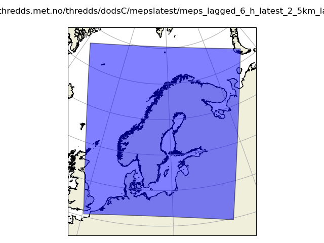
https://thredds.met.no/thredds/dodsC/mepslatest/meps_lagged_6_h_latest_2_5km_latest.nc
13:24:58 INFO opendrift.readers:67: Opening file with xr.open_dataset
13:24:59 DEBUG opendrift.readers.reader_netCDF_CF_generic:131: Finding coordinate variables.
13:24:59 DEBUG opendrift.readers.reader_netCDF_CF_generic:146: Parsing CF grid mapping dictionary: {'grid_mapping_name': 'lambert_conformal_conic', 'standard_parallel': array([63.3, 63.3]), 'longitude_of_central_meridian': np.float64(15.0), 'latitude_of_projection_origin': np.float64(63.3), 'earth_radius': np.float64(6371000.0)}
13:24:59 DEBUG pyproj:40: PROJ_ERROR: proj_create: several objects matching this name: Krovak (Greenwich), Equal Earth Greenwich, Laborde Grid (Greenwich), Modified Krovak (Greenwich), Krovak East North (Greenwich), Modified Krovak East North (Greenwich), ...
13:24:59 DEBUG opendrift.readers.reader_netCDF_CF_generic:245: 30 ensemble members available
13:24:59 INFO opendrift.readers.reader_netCDF_CF_generic:340: Detected dimensions: {'time': 'time', 'x': 'x', 'y': 'y'}
13:24:59 DEBUG opendrift.readers.reader_netCDF_CF_generic:376: Skipped variables without standard_name: ['fog_area_fraction']
13:24:59 DEBUG opendrift.readers.basereader.variables:546: Skipping calculation of vector component, since y is not north
13:24:59 DEBUG opendrift.readers.basereader.variables:546: Skipping calculation of vector component, since y is not north
13:24:59 DEBUG opendrift.readers.basereader.variables:546: Skipping calculation of vector component, since y is not north
13:24:59 DEBUG opendrift.readers.basereader.variables:546: Skipping calculation of vector component, since y is not north
13:24:59 DEBUG opendrift.readers.basereader.variables:618: Setting buffer size 10 for reader https://thredds.met.no/thredds/dodsC/mepslatest/meps_lagged_6_h_latest_2_5km_latest.nc, assuming a maximum average speed of 5 m/s and time span of 1:00:00
13:24:59 DEBUG opendrift.readers.basereader:185: Variable mapping: ['sea_floor_depth_below_sea_level'] -> ['land_binary_mask'] is not activated
13:24:59 DEBUG opendrift.readers.basereader.variables:573: Adding variable mapping: ['x_wind', 'y_wind'] -> wind_speed
===========================
Reader: https://thredds.met.no/thredds/dodsC/mepslatest/meps_lagged_6_h_latest_2_5km_latest.nc
Reader type: opendrift.readers.reader_netCDF_CF_generic
Projection:
+proj=lcc +lat_0=63.3 +lon_0=15 +lat_1=63.3 +lat_2=63.3 +x_0=0 +y_0=0 +R=6371000 +units=m +no_defs +type=crs
Coverage: [degrees]
xmin: -1060084.000000 xmax: 1309916.000000 step: 2500 numx: 949
ymin: -1332517.875000 ymax: 1337482.125000 step: 2500 numy: 1069
Corners (lon, lat):
(-18.12, 72.76) ( 54.24, 71.58)
( 0.28, 50.32) ( 33.03, 49.77)
Vertical levels [m]:
Not specified
Available time range:
start: 2026-07-14 11:00:00 end: 2026-07-17 00:00:00 step: 1:00:00
62 times (0 missing)
Variables (30 ensemble members):
x_wind
y_wind
air_temperature
relative_humidity
cloud_area_fraction
air_pressure_at_sea_level
precipitation_amount
snowfall_amount
wind_speed_of_gust
longitude
latitude
wind_speed - derived from ['x_wind', 'y_wind']
===========================
Time to open reader: 0:00:01.061074
#%
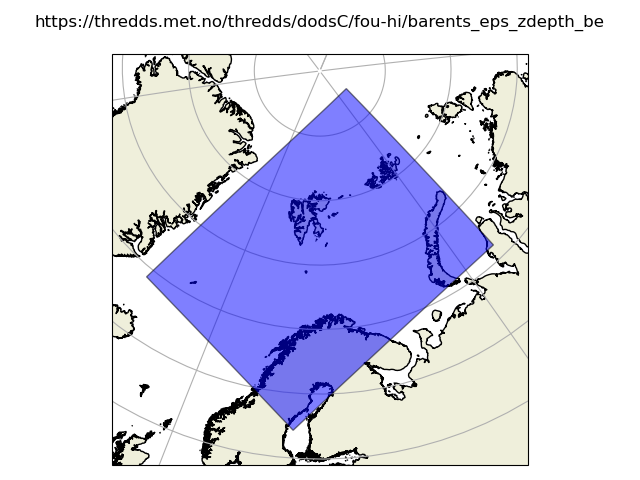
https://thredds.met.no/thredds/dodsC/fou-hi/barents_eps_zdepth_be
13:24:59 INFO opendrift.readers:67: Opening file with xr.open_dataset
13:25:02 DEBUG opendrift.readers.reader_netCDF_CF_generic:131: Finding coordinate variables.
13:25:02 DEBUG opendrift.readers.reader_netCDF_CF_generic:146: Parsing CF grid mapping dictionary: {'grid_mapping_name': 'lambert_conformal_conic', 'standard_parallel': array([77.5, 77.5], dtype=float32), 'longitude_of_central_meridian': np.float32(-25.0), 'latitude_of_projection_origin': np.float32(77.5), 'earth_radius': np.float32(6.371e+06), 'proj4': '+proj=lcc +lat_0=77.5 +lon_0=-25 +lat_1=77.5 +lat_2=77.5 +no_defs +R=6.371e+06'}
13:25:02 DEBUG pyproj:40: PROJ_ERROR: proj_create: several objects matching this name: Krovak (Greenwich), Equal Earth Greenwich, Laborde Grid (Greenwich), Modified Krovak (Greenwich), Krovak East North (Greenwich), Modified Krovak East North (Greenwich), ...
13:25:02 INFO opendrift.readers.reader_netCDF_CF_generic:340: Detected dimensions: {'x': 'X', 'y': 'Y', 'z': 'depth', 'time': 'time'}
13:25:02 DEBUG opendrift.readers.reader_netCDF_CF_generic:376: Skipped variables without standard_name: ['angle']
13:25:02 DEBUG opendrift.readers.basereader.variables:546: Skipping calculation of vector component, since y is not north
13:25:02 DEBUG opendrift.readers.basereader.variables:546: Skipping calculation of vector component, since y is not north
13:25:02 DEBUG opendrift.readers.basereader.variables:546: Skipping calculation of vector component, since y is not north
13:25:02 DEBUG opendrift.readers.basereader.variables:546: Skipping calculation of vector component, since y is not north
13:25:02 DEBUG opendrift.readers.basereader.variables:618: Setting buffer size 10 for reader https://thredds.met.no/thredds/dodsC/fou-hi/barents_eps_zdepth_be, assuming a maximum average speed of 5 m/s and time span of 1:00:00
13:25:02 INFO opendrift.readers.basereader:175: Variable x_sea_water_velocity will be rotated from eastward_sea_water_velocity
13:25:02 INFO opendrift.readers.basereader:175: Variable y_sea_water_velocity will be rotated from northward_sea_water_velocity
13:25:02 DEBUG opendrift.readers.basereader:185: Variable mapping: ['sea_floor_depth_below_sea_level'] -> ['land_binary_mask'] is not activated
13:25:02 DEBUG opendrift.readers.basereader.variables:573: Adding variable mapping: ['x_wind', 'y_wind'] -> wind_speed
13:25:02 DEBUG opendrift.readers.basereader.variables:573: Adding variable mapping: ['sea_ice_x_velocity', 'sea_ice_y_velocity'] -> sea_ice_speed
13:25:02 DEBUG opendrift.readers.basereader.variables:573: Adding variable mapping: ['x_sea_water_velocity', 'y_sea_water_velocity'] -> sea_water_speed
===========================
Reader: https://thredds.met.no/thredds/dodsC/fou-hi/barents_eps_zdepth_be
Reader type: opendrift.readers.reader_netCDF_CF_generic
Projection:
+proj=lcc +lat_0=77.5 +lon_0=-25 +lat_1=77.5 +lat_2=77.5 +x_0=0 +y_0=0 +R=6371000 +units=m +no_defs +type=crs
Coverage: [degrees]
xmin: 278603.187500 xmax: 2123602.750000 step: 2500 numx: 738
ymin: -897931.625000 ymax: 1472067.625000 step: 2500 numy: 948
Corners (lon, lat):
( 79.56, 87.57) ( 68.83, 71.11)
(-17.96, 69.30) ( 18.62, 62.13)
Vertical levels [m]:
[ -0. -3. -10. -15. -25. -50. -75. -100. -150. -200.
-250. -300. -500. -1000. -2000. -3000.]
Available time range:
start: 2022-06-29 00:00:00 end: 2026-07-18 00:00:00 step: 1:00:00
35521 times (672 missing)
Variables:
sea_floor_depth_below_sea_level
sea_binary_mask
ocean_vertical_diffusivity
x_wind
y_wind
sea_ice_area_fraction
sea_ice_thickness
sea_ice_x_velocity
sea_ice_y_velocity
sea_water_salinity
sea_water_temperature
eastward_sea_water_velocity
northward_sea_water_velocity
upward_sea_water_velocity
sea_surface_height
latitude
longitude
x_sea_water_velocity
y_sea_water_velocity
wind_speed - derived from ['x_wind', 'y_wind']
sea_ice_speed - derived from ['sea_ice_x_velocity', 'sea_ice_y_velocity']
sea_water_speed - derived from ['x_sea_water_velocity', 'y_sea_water_velocity']
===========================
Time to open reader: 0:00:03.198953
#%
https://thredds.met.no/thredds/dodsC/cmems/mywavewam3km/dataset-wam-arctic-1hr3km-be.ncml
13:25:02 INFO opendrift.readers:67: Opening file with xr.open_dataset
13:25:08 DEBUG opendrift.readers.reader_netCDF_CF_generic:131: Finding coordinate variables.
13:25:08 DEBUG opendrift.readers.reader_netCDF_CF_generic:146: Parsing CF grid mapping dictionary: {'grid_mapping_name': 'polar_stereographic', 'scale_factor_at_projection_origin': np.float64(1.0), 'straight_vertical_longitude_from_pole': np.float64(-45.0), 'latitude_of_projection_origin': np.float64(90.0), 'earth_radius': np.float64(6371000.0), 'proj4': '+proj=stere +lon_0=-45 +lat_0=90 +k=1 +R=6371000 +no_defs'}
13:25:08 DEBUG pyproj:40: PROJ_ERROR: proj_create: several objects matching this name: Krovak (Greenwich), Equal Earth Greenwich, Laborde Grid (Greenwich), Modified Krovak (Greenwich), Krovak East North (Greenwich), Modified Krovak East North (Greenwich), ...
13:25:08 INFO opendrift.readers.reader_netCDF_CF_generic:340: Detected dimensions: {'y': 'rlat', 'x': 'rlon', 'time': 'time'}
13:25:08 DEBUG opendrift.readers.basereader.variables:546: Skipping calculation of vector component, since y is not north
13:25:08 DEBUG opendrift.readers.basereader.variables:546: Skipping calculation of vector component, since y is not north
13:25:08 DEBUG opendrift.readers.basereader.variables:546: Skipping calculation of vector component, since y is not north
13:25:08 DEBUG opendrift.readers.basereader.variables:546: Skipping calculation of vector component, since y is not north
13:25:08 DEBUG opendrift.readers.basereader.variables:618: Setting buffer size 8 for reader https://thredds.met.no/thredds/dodsC/cmems/mywavewam3km/dataset-wam-arctic-1hr3km-be.ncml, assuming a maximum average speed of 5 m/s and time span of 1:00:00
13:25:08 DEBUG opendrift.readers.basereader:185: Variable mapping: ['sea_floor_depth_below_sea_level'] -> ['land_binary_mask'] is not activated
13:25:08 DEBUG opendrift.readers.basereader.variables:573: Adding variable mapping: ['sea_surface_wave_stokes_drift_x_velocity', 'sea_surface_wave_stokes_drift_y_velocity'] -> sea_surface_wave_stokes_drift_speed
===========================
Reader: https://thredds.met.no/thredds/dodsC/cmems/mywavewam3km/dataset-wam-arctic-1hr3km-be.ncml
Reader type: opendrift.readers.reader_netCDF_CF_generic
Projection:
+proj=stere +lat_0=90 +lon_0=-45 +k=1 +x_0=0 +y_0=0 +R=6371000 +units=m +no_defs +type=crs
Coverage: [degrees]
xmin: -3600000.000000 xmax: 3798000.000000 step: 3000 numx: 2467
ymin: -4300000.000000 ymax: 2798000.000000 step: 3000 numy: 2367
Corners (lon, lat):
(-172.86, 50.62) ( 81.38, 49.37)
(-84.94, 42.49) ( -3.55, 41.52)
Vertical levels [m]:
Not specified
Available time range:
start: 2022-08-01 00:00:00 end: 2026-07-23 12:00:00 step: 1:00:00
34861 times (0 missing)
Variables:
sea_floor_depth_below_sea_level
sea_ice_area_fraction
sea_ice_thickness
sea_water_speed
sea_water_to_direction
sea_surface_wave_significant_height
sea_surface_wave_period_at_variance_spectral_density_maximum
sea_surface_wave_mean_period_from_variance_spectral_density_inverse_frequency_moment
sea_surface_wave_mean_period_from_variance_spectral_density_second_frequency_moment
sea_surface_wave_from_direction
sea_surface_wind_wave_significant_height
sea_surface_wind_wave_mean_period_from_variance_spectral_density_first_frequency_moment
sea_surface_wind_wave_from_direction
sea_surface_primary_swell_wave_significant_height
sea_surface_primary_swell_wave_mean_period
sea_surface_primary_swell_wave_from_direction
sea_surface_secondary_swell_wave_significant_height
sea_surface_secondary_swell_wave_mean_period
sea_surface_secondary_swell_wave_from_direction
sea_surface_wave_from_direction_at_variance_spectral_density_maximum
sea_surface_wave_stokes_drift_x_velocity
sea_surface_wave_stokes_drift_y_velocity
sea_surface_wave_maximum_crest_height
sea_surface_wave_maximum_height
longitude
latitude
sea_surface_wave_stokes_drift_speed - derived from ['sea_surface_wave_stokes_drift_x_velocity', 'sea_surface_wave_stokes_drift_y_velocity']
===========================
Time to open reader: 0:00:05.648473
#%
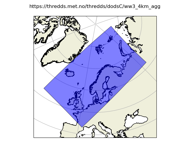
https://thredds.met.no/thredds/dodsC/ww3_4km_agg
13:25:08 INFO opendrift.readers:67: Opening file with xr.open_dataset
13:25:17 DEBUG opendrift.readers.reader_netCDF_CF_generic:131: Finding coordinate variables.
13:25:17 DEBUG opendrift.readers.reader_netCDF_CF_generic:146: Parsing CF grid mapping dictionary: {'proj4': '+proj=ob_tran +o_proj=longlat +lon_0=-40 +o_lat_p=22 +R=6.371e+06 +no_defs', 'grid_mapping_name': 'rotated_latitude_longitude', 'grid_north_pole_longitude': np.float64(140.0), 'grid_north_pole_latitude': np.float64(22.0), 'earth_radius': np.float64(6371000.0)}
13:25:17 DEBUG pyproj:40: PROJ_ERROR: proj_create: several objects matching this name: Krovak (Greenwich), Equal Earth Greenwich, Laborde Grid (Greenwich), Modified Krovak (Greenwich), Krovak East North (Greenwich), Modified Krovak East North (Greenwich), ...
13:25:17 INFO opendrift.readers.reader_netCDF_CF_generic:340: Detected dimensions: {'y': 'rlat', 'x': 'rlon', 'time': 'time'}
13:25:17 DEBUG opendrift.readers.basereader.variables:546: Skipping calculation of vector component, since y is not north
13:25:17 DEBUG opendrift.readers.basereader.variables:546: Skipping calculation of vector component, since y is not north
13:25:17 DEBUG opendrift.readers.basereader.variables:546: Skipping calculation of vector component, since y is not north
13:25:17 DEBUG opendrift.readers.basereader.variables:546: Skipping calculation of vector component, since y is not north
13:25:17 DEBUG opendrift.readers.basereader.variables:618: Setting buffer size 7 for reader https://thredds.met.no/thredds/dodsC/ww3_4km_agg, assuming a maximum average speed of 5 m/s and time span of 1:00:00
13:25:17 INFO opendrift.readers.basereader:175: Variable x_wind will be rotated from eastward_wind
13:25:17 INFO opendrift.readers.basereader:175: Variable y_wind will be rotated from northward_wind
13:25:17 INFO opendrift.readers.basereader:175: Variable sea_surface_wave_stokes_drift_x_velocity will be rotated from eastward_surface_stokes_drift
13:25:17 INFO opendrift.readers.basereader:175: Variable sea_surface_wave_stokes_drift_y_velocity will be rotated from northward_surface_stokes_drift
13:25:17 DEBUG opendrift.readers.basereader:185: Variable mapping: ['sea_floor_depth_below_sea_level'] -> ['land_binary_mask'] is not activated
13:25:17 DEBUG opendrift.readers.basereader.variables:573: Adding variable mapping: ['sea_surface_wave_stokes_drift_x_velocity', 'sea_surface_wave_stokes_drift_y_velocity'] -> sea_surface_wave_stokes_drift_speed
13:25:17 DEBUG opendrift.readers.basereader.variables:119: NB: Converting degrees to radians due to ob_tran srs
===========================
Reader: https://thredds.met.no/thredds/dodsC/ww3_4km_agg
Reader type: opendrift.readers.reader_netCDF_CF_generic
Projection:
+proj=ob_tran +o_proj=longlat +o_lon_p=0 +o_lat_p=22 +lon_0=320 +R=6371000 +no_defs +type=crs
Coverage: [degrees]
xmin: 5.530000 xmax: 30.450000 step: 0.04 numx: 623
ymin: -14.350000 ymax: 26.650000 step: 0.04 numy: 1026
Corners (lon, lat):
( 93.81, 83.15) ( 65.69, 61.93)
(-31.02, 53.25) ( 2.14, 42.96)
Vertical levels [m]:
Not specified
Available time range:
start: 2023-04-20 06:00:00 end: 2026-07-16 05:00:00 step: 1:00:00
28392 times (0 missing)
Variables:
longitude
latitude
status map
sea_surface_wave_peak_frequency
depth
eastward_wind
northward_wind
sea_ice_area_fraction
sea_surface_wave_significant_height
mean_wave_length
sea_surface_wind_wave_mean_period_from_variance_spectral_density_second_frequency_moment
sea_surface_wind_wave_mean_period_from_variance_spectral_density_inverse_frequency_moment
sea_surface_wind_wave_mean_period_from_variance_spectral_density_first_frequency_moment
sea_surface_wave_from_direction
sea_surface_wave_directional_spread
sea_surface_wave_peak_direction
sea_surface_wave_maximum_height
sea_surface_wave_maximum_crest_height
sea_surface_wave_maximum_height_std
sea_surface_wave_maximum_crest_height_std
sea_surface_wave_significant_height_partition_0
sea_surface_wave_significant_height_partition_1
sea_surface_wave_period_at_variance_spectral_density_maximum_partition_0
sea_surface_wave_period_at_variance_spectral_density_maximum_partition_1
sea_surface_wave_from_direction_partition_0
sea_surface_wave_from_direction_partition_1
sea_surface_swell_wave_mean_period_from_variance_spectral_density_first_frequency_moment
sea_surface_swell_wave_mean_period_from_variance_spectral_density_second_frequency_moment
eastward_friction_velocity
northward_friction_velocity
charnock_coefficient_for_surface_roughness_length_for_momentum_in_air
wind_mixing_energy_flux_into_sea_water
eastward_wave_supported_wind_stress
northward_wave_supported_wind_stress
sea_surface_wave_mean_period_from_variance_spectral_density_inverse_frequency_moment
eastward_wave_to_ocean_stress
northward_wave_to_ocean_stress
wave_to_ocean_energy_flux
eastward_stokes_transport
northward_stokes_transport
eastward_surface_stokes_drift
northward_surface_stokes_drift
eastward_wave_to_sea_ice_stress
northward_wave_to_sea_ice_stress
wave_to_sea_ice_energy_flux
sea_surface_wave_period_at_variance_spectral_density_maximum
wind_speed
wind_from_direction
x_wind
y_wind
sea_surface_wave_stokes_drift_x_velocity
sea_surface_wave_stokes_drift_y_velocity
sea_surface_wave_stokes_drift_speed - derived from ['sea_surface_wave_stokes_drift_x_velocity', 'sea_surface_wave_stokes_drift_y_velocity']
===========================
Time to open reader: 0:00:08.847114
13:25:17 DEBUG opendrift.readers.basereader.variables:119: NB: Converting degrees to radians due to ob_tran srs
13:25:17 DEBUG opendrift.readers.basereader.variables:119: NB: Converting degrees to radians due to ob_tran srs
13:25:17 DEBUG opendrift.readers.basereader.variables:119: NB: Converting degrees to radians due to ob_tran srs
#%
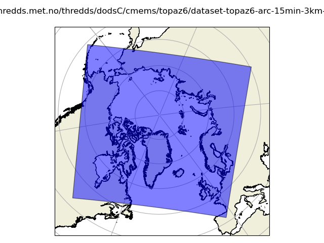
https://thredds.met.no/thredds/dodsC/cmems/topaz6/dataset-topaz6-arc-15min-3km-be.ncml
13:25:17 INFO opendrift.readers:67: Opening file with xr.open_dataset
13:25:24 DEBUG opendrift.readers.reader_netCDF_CF_generic:131: Finding coordinate variables.
13:25:24 DEBUG opendrift.readers.reader_netCDF_CF_generic:146: Parsing CF grid mapping dictionary: {'grid_mapping_name': 'polar_stereographic', 'latitude_of_projection_origin': np.float64(90.0), 'longitude_of_projection_origin': np.float64(-45.0), 'scale_factor_at_projection_origin': np.float64(1.0), 'straight_vertical_longitude_from_pole': np.float64(-45.0), 'earth_radius': np.float64(6378273.0), 'proj4': '+proj=stere +lon_0=-45 +lat_0=90 +k=1 +R=6378273 +no_defs', 'false_easting': np.float64(0.0), 'false_northing': np.float64(0.0)}
13:25:24 DEBUG pyproj:40: PROJ_ERROR: proj_create: several objects matching this name: Krovak (Greenwich), Equal Earth Greenwich, Laborde Grid (Greenwich), Modified Krovak (Greenwich), Krovak East North (Greenwich), Modified Krovak East North (Greenwich), ...
13:25:24 INFO opendrift.readers.reader_netCDF_CF_generic:340: Detected dimensions: {'x': 'x', 'y': 'y', 'time': 'time'}
13:25:24 DEBUG opendrift.readers.basereader.variables:546: Skipping calculation of vector component, since y is not north
13:25:24 DEBUG opendrift.readers.basereader.variables:546: Skipping calculation of vector component, since y is not north
13:25:24 DEBUG opendrift.readers.basereader.variables:546: Skipping calculation of vector component, since y is not north
13:25:24 DEBUG opendrift.readers.basereader.variables:546: Skipping calculation of vector component, since y is not north
13:25:24 DEBUG opendrift.readers.basereader.variables:618: Setting buffer size 4 for reader https://thredds.met.no/thredds/dodsC/cmems/topaz6/dataset-topaz6-arc-15min-3km-be.ncml, assuming a maximum average speed of 5 m/s and time span of 0:15:00
13:25:24 DEBUG opendrift.readers.basereader:185: Variable mapping: ['sea_floor_depth_below_sea_level'] -> ['land_binary_mask'] is not activated
13:25:24 DEBUG opendrift.readers.basereader.variables:573: Adding variable mapping: ['x_sea_water_velocity', 'y_sea_water_velocity'] -> sea_water_speed
===========================
Reader: https://thredds.met.no/thredds/dodsC/cmems/topaz6/dataset-topaz6-arc-15min-3km-be.ncml
Reader type: opendrift.readers.reader_netCDF_CF_generic
Projection:
+proj=stere +lat_0=90 +lon_0=-45 +k=1 +x_0=0 +y_0=0 +R=6378273 +units=m +no_defs +type=crs
Coverage: [degrees]
xmin: -3600000.000000 xmax: 3798000.000000 step: 3000 numx: 2467
ymin: -4300000.000000 ymax: 2798000.000000 step: 3000 numy: 2367
Corners (lon, lat):
(-172.86, 50.66) ( 81.38, 49.41)
(-84.94, 42.54) ( -3.55, 41.57)
Vertical levels [m]:
Not specified
Available time range:
start: 2018-01-01 00:00:00 end: 2026-07-22 23:45:00 step: 0:15:00
300000 times (0 missing)
Variables:
sea_floor_depth_below_sea_level
x_sea_water_velocity
y_sea_water_velocity
sea_surface_height
longitude
latitude
sea_water_speed - derived from ['x_sea_water_velocity', 'y_sea_water_velocity']
===========================
Time to open reader: 0:00:07.403829
#%
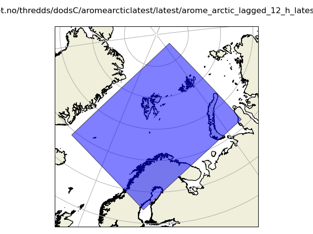
https://thredds.met.no/thredds/dodsC/aromearcticlatest/latest/arome_arctic_lagged_6_h_latest_2_5km_latest.nc
13:25:25 INFO opendrift.readers:67: Opening file with xr.open_dataset
13:25:25 DEBUG opendrift.readers.reader_netCDF_CF_generic:131: Finding coordinate variables.
13:25:25 DEBUG opendrift.readers.reader_netCDF_CF_generic:146: Parsing CF grid mapping dictionary: {'grid_mapping_name': 'lambert_conformal_conic', 'standard_parallel': array([77.5, 77.5]), 'longitude_of_central_meridian': np.float64(-25.0), 'latitude_of_projection_origin': np.float64(77.5), 'earth_radius': np.float64(6371000.0)}
13:25:25 DEBUG pyproj:40: PROJ_ERROR: proj_create: several objects matching this name: Krovak (Greenwich), Equal Earth Greenwich, Laborde Grid (Greenwich), Modified Krovak (Greenwich), Krovak East North (Greenwich), Modified Krovak East North (Greenwich), ...
13:25:25 DEBUG opendrift.readers.reader_netCDF_CF_generic:245: 6 ensemble members available
13:25:25 INFO opendrift.readers.reader_netCDF_CF_generic:340: Detected dimensions: {'time': 'time', 'x': 'x', 'y': 'y'}
13:25:25 DEBUG opendrift.readers.reader_netCDF_CF_generic:376: Skipped variables without standard_name: ['fog_area_fraction']
13:25:25 DEBUG opendrift.readers.basereader.variables:546: Skipping calculation of vector component, since y is not north
13:25:25 DEBUG opendrift.readers.basereader.variables:546: Skipping calculation of vector component, since y is not north
13:25:25 DEBUG opendrift.readers.basereader.variables:546: Skipping calculation of vector component, since y is not north
13:25:25 DEBUG opendrift.readers.basereader.variables:546: Skipping calculation of vector component, since y is not north
13:25:25 DEBUG opendrift.readers.basereader.variables:618: Setting buffer size 10 for reader https://thredds.met.no/thredds/dodsC/aromearcticlatest/latest/arome_arctic_lagged_6_h_latest_2_5km_latest.nc, assuming a maximum average speed of 5 m/s and time span of 1:00:00
13:25:25 DEBUG opendrift.readers.basereader:185: Variable mapping: ['sea_floor_depth_below_sea_level'] -> ['land_binary_mask'] is not activated
13:25:25 DEBUG opendrift.readers.basereader.variables:573: Adding variable mapping: ['x_wind', 'y_wind'] -> wind_speed
===========================
Reader: https://thredds.met.no/thredds/dodsC/aromearcticlatest/latest/arome_arctic_lagged_6_h_latest_2_5km_latest.nc
Reader type: opendrift.readers.reader_netCDF_CF_generic
Projection:
+proj=lcc +lat_0=77.5 +lon_0=-25 +lat_1=77.5 +lat_2=77.5 +x_0=0 +y_0=0 +R=6371000 +units=m +no_defs +type=crs
Coverage: [degrees]
xmin: 278620.937500 xmax: 2123621.000000 step: 2500 numx: 739
ymin: -897985.687500 ymax: 1472014.250000 step: 2500 numy: 949
Corners (lon, lat):
( 79.55, 87.57) ( 68.83, 71.11)
(-17.96, 69.30) ( 18.62, 62.13)
Vertical levels [m]:
Not specified
Available time range:
start: 2026-07-14 09:00:00 end: 2026-07-16 22:00:00 step: 1:00:00
62 times (0 missing)
Variables (6 ensemble members):
x_wind
y_wind
air_temperature
relative_humidity
cloud_area_fraction
air_pressure_at_sea_level
precipitation_amount
snowfall_amount
wind_speed_of_gust
longitude
latitude
wind_speed - derived from ['x_wind', 'y_wind']
===========================
Time to open reader: 0:00:00.920154
#%
https://thredds.ucar.edu/thredds/dodsC/grib/NCEP/GFS/Global_0p25deg/Best
13:25:26 INFO opendrift.readers:67: Opening file with xr.open_dataset
13:25:26 DEBUG opendrift.readers:128: Selecting GRIB variable u-component_of_wind_height_above_ground at 10m height and adding standard_name eastward_wind
13:25:26 DEBUG opendrift.readers:128: Selecting GRIB variable v-component_of_wind_height_above_ground at 10m height and adding standard_name northward_wind
13:25:26 DEBUG opendrift.readers.reader_netCDF_CF_generic:131: Finding coordinate variables.
13:25:26 DEBUG opendrift.readers.reader_netCDF_CF_generic:146: Parsing CF grid mapping dictionary: {'grid_mapping_name': 'latitude_longitude', 'earth_radius': np.float64(6371229.0), '_CoordinateTransformType': 'Projection', '_CoordinateAxisTypes': 'Lat Lon'}
13:25:27 DEBUG pyproj:40: PROJ_ERROR: proj_create: several objects matching this name: Krovak (Greenwich), Equal Earth Greenwich, Laborde Grid (Greenwich), Modified Krovak (Greenwich), Krovak East North (Greenwich), Modified Krovak East North (Greenwich), ...
13:25:27 DEBUG opendrift.readers.reader_netCDF_CF_generic:270: Lon and lat are 1D arrays - using as projection coordinates
13:25:27 INFO opendrift.readers.reader_netCDF_CF_generic:340: Detected dimensions: {'time': ['time', 'time1', 'time2', 'time3'], 'x': 'lon', 'y': 'lat'}
13:25:27 DEBUG opendrift.readers.reader_netCDF_CF_generic:376: Skipped variables without standard_name: ['time2_bounds', 'time3_bounds', 'pressure_difference_layer_bounds', 'depth_below_surface_layer_bounds', 'height_above_ground_layer_bounds', 'height_above_ground_layer1_bounds', 'pressure_difference_layer1_bounds', 'pressure_difference_layer2_bounds', 'sigma_layer_bounds', 'Total_ozone_entire_atmosphere_single_layer', 'Ozone_Mixing_Ratio_isobaric', 'Total_cloud_cover_entire_atmosphere_Mixed_intervals_Average', 'Low_cloud_cover_low_cloud_Mixed_intervals_Average', 'Temperature_middle_cloud_top_Mixed_intervals_Average', 'Temperature_high_cloud_top_Mixed_intervals_Average', 'Temperature_low_cloud_top_Mixed_intervals_Average', 'Surface_Lifted_Index_surface', 'Pressure_convective_cloud_bottom', 'Pressure_convective_cloud_top', 'Vertical_Speed_Shear_potential_vorticity_surface', 'Vertical_Speed_Shear_tropopause', 'Ventilation_Rate_planetary_boundary', 'MSLP_Eta_model_reduction_msl', 'Pressure_of_level_from_which_parcel_was_lifted_pressure_difference_layer', 'Liquid_Volumetric_Soil_Moisture_non_Frozen_depth_below_surface_layer', 'Wind_speed_gust_surface', 'Precipitation_rate_surface_Mixed_intervals_Average', 'Categorical_Rain_surface', 'Potential_Evaporation_Rate_surface', 'Volumetric_Soil_Moisture_Content_depth_below_surface_layer', 'Albedo_surface_Mixed_intervals_Average', 'Latent_heat_net_flux_surface_Mixed_intervals_Average', 'Sensible_heat_net_flux_surface_Mixed_intervals_Average', 'Land_cover_0__sea_1__land_surface', 'Ice_cover_surface', 'Momentum_flux_u-component_surface_Mixed_intervals_Average', 'Pressure_surface', 'Soil_type_surface', 'Specific_humidity_pressure_difference_layer', 'Temperature_pressure_difference_layer', 'Temperature_surface', 'Visibility_surface', 'Ice_thickness_surface', 'Relative_humidity_sigma_layer', 'Relative_humidity_pressure_difference_layer', 'Surface_roughness_surface', 'Haines_index_surface', 'Soil_temperature_depth_below_surface_layer', 'u-component_of_wind_pressure_difference_layer', 'Momentum_flux_v-component_surface_Mixed_intervals_Average', 'Categorical_Rain_surface_Mixed_intervals_Average', 'v-component_of_wind_pressure_difference_layer', 'Vegetation_surface', 'Geopotential_height_surface', 'Convective_available_potential_energy_pressure_difference_layer', 'Convective_available_potential_energy_surface', 'Convective_inhibition_pressure_difference_layer', 'Convective_inhibition_surface', 'Precipitation_rate_surface', 'Ice_temperature_surface', 'Storm_relative_helicity_height_above_ground_layer', 'Snow_depth_surface', 'Water_equivalent_of_accumulated_snow_depth_surface', 'Ground_Heat_Flux_surface_Mixed_intervals_Average', 'Total_cloud_cover_convective_cloud', 'Sunshine_Duration_surface', 'Best_4_layer_Lifted_Index_surface', 'Water_runoff_surface_Mixed_intervals_Accumulation', 'Relative_humidity_highest_tropospheric_freezing', 'Relative_humidity_entire_atmosphere_single_layer', 'Categorical_Freezing_Rain_surface', 'Wilting_Point_surface', 'Total_precipitation_surface_Mixed_intervals_Accumulation', 'Convective_precipitation_surface_Mixed_intervals_Accumulation', 'Pressure_low_cloud_bottom_Mixed_intervals_Average', 'Pressure_high_cloud_bottom_Mixed_intervals_Average', 'Pressure_low_cloud_top_Mixed_intervals_Average', 'Pressure_middle_cloud_bottom_Mixed_intervals_Average', 'Pressure_middle_cloud_top_Mixed_intervals_Average', 'Pressure_high_cloud_top_Mixed_intervals_Average', 'Categorical_Freezing_Rain_surface_Mixed_intervals_Average', 'Convective_precipitation_rate_surface', 'Per_cent_frozen_precipitation_surface', 'Specific_humidity_isobaric', 'Temperature_isobaric', 'Relative_humidity_isobaric', 'Relative_humidity_zeroDegC_isotherm', 'Total_cloud_cover_isobaric', 'u-component_of_wind_isobaric', 'Total_cloud_cover_boundary_layer_cloud_Mixed_intervals_Average', 'Downward_Short-Wave_Radiation_Flux_surface_Mixed_intervals_Average', 'Cloud_Work_Function_entire_atmosphere_single_layer_Mixed_intervals_Average', 'v-component_of_wind_isobaric', 'Maximum_temperature_height_above_ground_Mixed_intervals_Maximum', 'Geopotential_height_isobaric', 'Geopotential_height_zeroDegC_isotherm', 'U-Component_Storm_Motion_height_above_ground_layer', 'u-component_of_wind_planetary_boundary', 'Categorical_Ice_Pellets_surface', 'Vertical_velocity_pressure_isobaric', 'Vertical_velocity_geometric_isobaric', 'Absolute_vorticity_isobaric', 'Pressure_reduced_to_MSL_msl', 'Categorical_Ice_Pellets_surface_Mixed_intervals_Average', 'Meridional_Flux_of_Gravity_Wave_Stress_surface_Mixed_intervals_Average', 'Downward_Long-Wave_Radp_Flux_surface_Mixed_intervals_Average', 'Cloud_mixing_ratio_isobaric', 'Ice_water_mixing_ratio_isobaric', 'Rain_mixing_ratio_isobaric', 'Snow_mixing_ratio_isobaric', 'Graupel_snow_pellets_isobaric', 'Pressure_maximum_wind', 'Temperature_maximum_wind', 'Temperature_altitude_above_msl', 'u-component_of_wind_altitude_above_msl', 'u-component_of_wind_maximum_wind', 'ICAO_Standard_Atmosphere_Reference_Height_maximum_wind', 'Upward_Short-Wave_Radiation_Flux_surface_Mixed_intervals_Average', 'Upward_Short-Wave_Radiation_Flux_atmosphere_top_Mixed_intervals_Average', 'v-component_of_wind_maximum_wind', 'v-component_of_wind_altitude_above_msl', 'Low_cloud_cover_low_cloud', 'Apparent_temperature_height_above_ground', 'Geopotential_height_maximum_wind', 'Minimum_temperature_height_above_ground_Mixed_intervals_Minimum', 'Ice_growth_rate_altitude_above_msl', 'V-Component_Storm_Motion_height_above_ground_layer', 'Field_Capacity_surface', 'v-component_of_wind_planetary_boundary', 'Precipitable_water_entire_atmosphere_single_layer', 'Categorical_Snow_surface', 'Reflectivity_hybrid', 'Reflectivity_height_above_ground', 'Pressure_height_above_ground', 'Pressure_tropopause', 'Specific_humidity_height_above_ground', 'Temperature_tropopause', 'Temperature_height_above_ground', 'Relative_humidity_height_above_ground', 'u-component_of_wind_tropopause', 'ICAO_Standard_Atmosphere_Reference_Height_tropopause', 'Categorical_Snow_surface_Mixed_intervals_Average', 'Zonal_Flux_of_Gravity_Wave_Stress_surface_Mixed_intervals_Average', 'Upward_Long-Wave_Radp_Flux_atmosphere_top_Mixed_intervals_Average', 'Upward_Long-Wave_Radp_Flux_surface_Mixed_intervals_Average', 'v-component_of_wind_tropopause', 'Geopotential_height_tropopause', 'Dewpoint_temperature_height_above_ground', 'Temperature_sigma', 'Relative_humidity_sigma', 'Potential_temperature_sigma', 'u-component_of_wind_sigma', 'v-component_of_wind_sigma', 'Medium_cloud_cover_middle_cloud', 'Cloud_mixing_ratio_hybrid', 'Planetary_Boundary_Layer_Height_surface', 'Ice_water_mixing_ratio_hybrid', 'Plant_Canopy_Surface_Water_surface', 'Rain_mixing_ratio_hybrid', 'Vertical_velocity_pressure_sigma', 'Snow_mixing_ratio_hybrid', 'Composite_reflectivity_entire_atmosphere', 'Convective_Precipitation_Rate_surface_Mixed_intervals_Average', 'Total_cloud_cover_entire_atmosphere', 'High_cloud_cover_high_cloud', 'Geopotential_height_cloud_ceiling', 'Geopotential_height_highest_tropospheric_freezing', 'Frictional_Velocity_surface', 'Graupel_snow_pellets_hybrid', 'High_cloud_cover_high_cloud_Mixed_intervals_Average', 'Cloud_water_entire_atmosphere_single_layer', 'Pressure_potential_vorticity_surface', 'Temperature_potential_vorticity_surface', 'u-component_of_wind_potential_vorticity_surface', 'v-component_of_wind_potential_vorticity_surface', 'Geopotential_height_potential_vorticity_surface', 'Medium_cloud_cover_middle_cloud_Mixed_intervals_Average']
13:25:27 DEBUG opendrift.readers.reader_netCDF_CF_generic:396: Several time dimensions detected: ['time', 'time1', 'time2', 'time3']: Using single time dimension found in detected variables: ['time1']
13:25:27 DEBUG opendrift.readers.basereader.variables:546: Skipping calculation of vector component, since y is not north
13:25:27 DEBUG opendrift.readers.basereader.variables:546: Skipping calculation of vector component, since y is not north
13:25:27 DEBUG opendrift.readers.basereader.variables:546: Skipping calculation of vector component, since y is not north
13:25:27 DEBUG opendrift.readers.basereader.variables:546: Skipping calculation of vector component, since y is not north
13:25:27 DEBUG opendrift.readers.basereader.variables:618: Setting buffer size 4 for reader https://thredds.ucar.edu/thredds/dodsC/grib/NCEP/GFS/Global_0p25deg/Best, assuming a maximum average speed of 5 m/s and time span of 3:00:00
13:25:27 INFO opendrift.readers.basereader:175: Variable x_wind will be rotated from eastward_wind
13:25:27 INFO opendrift.readers.basereader:175: Variable y_wind will be rotated from northward_wind
13:25:27 DEBUG opendrift.readers.basereader:185: Variable mapping: ['sea_floor_depth_below_sea_level'] -> ['land_binary_mask'] is not activated
13:25:27 DEBUG opendrift.readers.basereader.variables:573: Adding variable mapping: ['x_wind', 'y_wind'] -> wind_speed
===========================
Reader: https://thredds.ucar.edu/thredds/dodsC/grib/NCEP/GFS/Global_0p25deg/Best
Reader type: opendrift.readers.reader_netCDF_CF_generic
Projection:
+proj=longlat +R=6371229 +no_defs +type=crs
Coverage: [degrees]
xmin: 0.000000 xmax: 359.750000 step: 0.25 numx: 1440
ymin: -90.000000 ymax: 90.000000 step: 0.25 numy: 721
Corners (lon, lat):
( 0.00, 90.00) (359.75, 90.00)
( 0.00, -90.00) (359.75, -90.00)
Vertical levels [m]:
Not specified
Available time range:
start: 2026-07-07 03:00:00 end: 2026-07-30 06:00:00 step: 3:00:00
186 times (-155 missing)
Variables:
eastward_wind
northward_wind
x_wind
y_wind
wind_speed - derived from ['x_wind', 'y_wind']
===========================
Time to open reader: 0:00:00.895028
#%
https://pae-paha.pacioos.hawaii.edu/thredds/dodsC/ncep_global/NCEP_Global_Atmospheric_Model_best.ncd
13:25:27 INFO opendrift.readers:67: Opening file with xr.open_dataset
13:25:29 DEBUG opendrift.readers.reader_netCDF_CF_generic:131: Finding coordinate variables.
13:25:29 DEBUG opendrift.readers.reader_netCDF_CF_generic:270: Lon and lat are 1D arrays - using as projection coordinates
13:25:29 INFO opendrift.readers.reader_netCDF_CF_generic:340: Detected dimensions: {'time': 'time', 'x': 'longitude', 'y': 'latitude'}
13:25:29 DEBUG opendrift.readers.basereader.variables:618: Setting buffer size 3 for reader https://pae-paha.pacioos.hawaii.edu/thredds/dodsC/ncep_global/NCEP_Global_Atmospheric_Model_best.ncd, assuming a maximum average speed of 5 m/s and time span of 3:00:00
13:25:29 INFO opendrift.readers.basereader:175: Variable x_wind will be rotated from eastward_wind
13:25:29 INFO opendrift.readers.basereader:175: Variable y_wind will be rotated from northward_wind
13:25:29 DEBUG opendrift.readers.basereader:185: Variable mapping: ['sea_floor_depth_below_sea_level'] -> ['land_binary_mask'] is not activated
13:25:29 DEBUG opendrift.readers.basereader.variables:573: Adding variable mapping: ['x_wind', 'y_wind'] -> wind_speed
===========================
Reader: https://pae-paha.pacioos.hawaii.edu/thredds/dodsC/ncep_global/NCEP_Global_Atmospheric_Model_best.ncd
Reader type: opendrift.readers.reader_netCDF_CF_generic
Projection:
+proj=latlong
Coverage: [degrees]
xmin: 0.000000 xmax: 359.500000 step: 0.5 numx: 720
ymin: -90.000000 ymax: 90.000000 step: 0.5 numy: 361
Corners (lon, lat):
( 0.00, 90.00) (359.50, 90.00)
( 0.00, -90.00) (359.50, -90.00)
Vertical levels [m]:
Not specified
Available time range:
start: 2022-12-01 12:00:00 end: 2026-07-21 15:00:00 step: 3:00:00
10626 times (0 missing)
Variables:
air_pressure_at_sea_level
surface_temperature
precipitation_flux
surface_downwelling_shortwave_flux
surface_downwelling_longwave_flux
surface_upwelling_shortwave_flux
surface_upwelling_longwave_flux
air_temperature
relative_humidity
eastward_wind
northward_wind
x_wind
y_wind
wind_speed - derived from ['x_wind', 'y_wind']
===========================
Time to open reader: 0:00:01.904993
#%
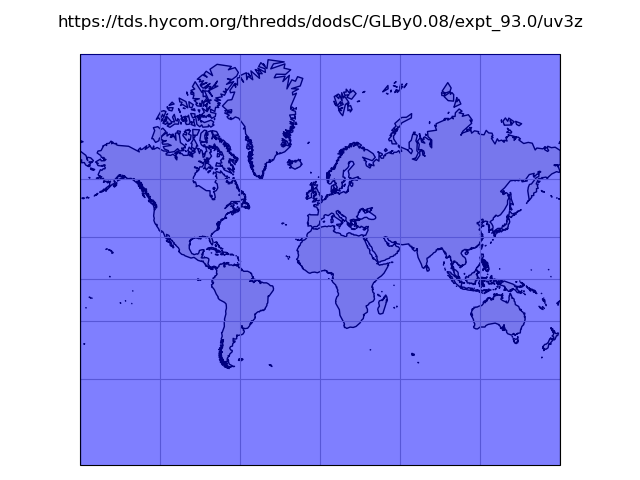
https://tds.hycom.org/thredds/dodsC/FMRC_ESPC-D-V02_uv3z/FMRC_ESPC-D-V02_uv3z_best.ncd
13:25:29 INFO opendrift.readers:67: Opening file with xr.open_dataset
13:25:29 WARNING opendrift.readers:75: Removing variables that cannot be CF decoded: ['tau']
13:25:29 DEBUG opendrift.readers.reader_netCDF_CF_generic:131: Finding coordinate variables.
13:25:29 INFO opendrift.readers.reader_netCDF_CF_generic:307: Grid coordinates are detected, but proj4 string not given: assuming latlong
13:25:29 INFO opendrift.readers.reader_netCDF_CF_generic:340: Detected dimensions: {'z': 'depth', 'y': 'lat', 'x': 'lon', 'time': 'time'}
13:25:29 DEBUG opendrift.readers.basereader.variables:618: Setting buffer size 9 for reader https://tds.hycom.org/thredds/dodsC/FMRC_ESPC-D-V02_uv3z/FMRC_ESPC-D-V02_uv3z_best.ncd, assuming a maximum average speed of 5 m/s and time span of 3:00:00
13:25:29 INFO opendrift.readers.basereader:175: Variable x_sea_water_velocity will be rotated from eastward_sea_water_velocity
13:25:29 INFO opendrift.readers.basereader:175: Variable y_sea_water_velocity will be rotated from northward_sea_water_velocity
13:25:29 DEBUG opendrift.readers.basereader:185: Variable mapping: ['sea_floor_depth_below_sea_level'] -> ['land_binary_mask'] is not activated
13:25:29 DEBUG opendrift.readers.basereader.variables:573: Adding variable mapping: ['x_sea_water_velocity', 'y_sea_water_velocity'] -> sea_water_speed
===========================
Reader: https://tds.hycom.org/thredds/dodsC/FMRC_ESPC-D-V02_uv3z/FMRC_ESPC-D-V02_uv3z_best.ncd
Reader type: opendrift.readers.reader_netCDF_CF_generic
Projection:
+proj=latlong
Coverage: [degrees]
xmin: 0.000000 xmax: 359.920044 step: 0.0799561 numx: 4502
ymin: -80.000000 ymax: 90.000000 step: 0.0400009 numy: 4250
Corners (lon, lat):
( 0.00, 90.00) (359.92, 90.00)
( 0.00, -80.00) (359.92, -80.00)
Vertical levels [m]:
[ -0. -2. -4. -6. -8. -10. -12. -15. -20. -25.
-30. -35. -40. -45. -50. -60. -70. -80. -90. -100.
-125. -150. -200. -250. -300. -350. -400. -500. -600. -700.
-800. -900. -1000. -1250. -1500. -2000. -2500. -3000. -4000. -5000.]
Available time range:
start: 2026-07-05 12:00:00 end: 2026-07-21 12:00:00 step: 3:00:00
129 times (0 missing)
Variables:
eastward_sea_water_velocity
northward_sea_water_velocity
x_sea_water_velocity
y_sea_water_velocity
sea_water_speed - derived from ['x_sea_water_velocity', 'y_sea_water_velocity']
===========================
Time to open reader: 0:00:00.416259
Summary of times to open each dataset:
for t, time in times.items():
    print(time, t)
0:00:03.108272 https://thredds.met.no/thredds/dodsC/fou-hi/norkystv3_800m_m00_be
0:00:01.061074 https://thredds.met.no/thredds/dodsC/mepslatest/meps_lagged_6_h_latest_2_5km_latest.nc
0:00:03.198953 https://thredds.met.no/thredds/dodsC/fou-hi/barents_eps_zdepth_be
0:00:05.648473 https://thredds.met.no/thredds/dodsC/cmems/mywavewam3km/dataset-wam-arctic-1hr3km-be.ncml
0:00:08.847114 https://thredds.met.no/thredds/dodsC/ww3_4km_agg
0:00:07.403829 https://thredds.met.no/thredds/dodsC/cmems/topaz6/dataset-topaz6-arc-15min-3km-be.ncml
0:00:00.920154 https://thredds.met.no/thredds/dodsC/aromearcticlatest/latest/arome_arctic_lagged_6_h_latest_2_5km_latest.nc
0:00:00.895028 https://thredds.ucar.edu/thredds/dodsC/grib/NCEP/GFS/Global_0p25deg/Best
0:00:01.904993 https://pae-paha.pacioos.hawaii.edu/thredds/dodsC/ncep_global/NCEP_Global_Atmospheric_Model_best.ncd
0:00:00.416259 https://tds.hycom.org/thredds/dodsC/FMRC_ESPC-D-V02_uv3z/FMRC_ESPC-D-V02_uv3z_best.ncd
Total running time of the script: (1 minutes 43.076 seconds)